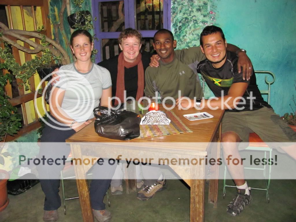
Thursday, November 25, 2010

Sleepy San Juan del Sur

Daryll writes:

After leaving Granada still high on adrenaline, we made the short ride to San Juan del Sur, a  sleepy beach town on the Pacific Coast.  It was a relatively easy ride and  we arrived at our destination around 10:30am; the earliest we’ve ever been at a destination, so took the time to shop around for a cheap hostel that also had secure parking.  English is commonly heard on the streets as it is home to several ex-pats that either run business’s or have vacation homes here – rough life.  The beach-front is littered with bar’s and restaurants that offer a spectacular view of the bay. 


 We decided to spend 2 days here and plan our route through Costa Rica and it so happens, we may just end up having to ride through San Jose, yet another capital city.  We might hit a record.  Prior to arriving in Nicaragua, I had this preconceived notion that it was going to be infested with drug lords, that it would be an extremely dangerous country and the people won’t be friendly towards tourists.  To the contrary, Nicaragua has blown me away.  It is by far one of the safest country’s we have traveled through thus far and the people have been unbelievably friendly towards us.  Nicaragua has a lot to offer.  Tomorrow we are off for yet another border crossing. 


New photos added to the Nicaragua photo album.
Digg this

Tuesday, November 23, 2010

Zip-Trekking in Granada

Daryll writes:

With a few extra days in Granada, we decided to do our research on Costa Rica and after speaking with several other travelers realized that we could do some of the activities that we wanted to do in Costa Rica in Nicaragua  at a lower cost.  One of the activities was to do a zip-trek through a semi-cloud forest.


Zip-Trek Canopy Tour from Daryll Naidu on Vimeo.
Digg this

Monday, November 22, 2010

Granada, Nicaragua

Daryll writes:

Whilst in Leon, we met a retired Canadian couple (David & Theresa) from Ontario that now call Nicaragua home.  David had given us some rough directions on how to navigate through Managua and together with my GPS, we made easy work of the city.  We also benefited from the fact that it was Sunday morning and most people where either at church or still in bed as the roads were relatively quiet.  I’m using Open Street Mapping for Central and South America on my Garmin GPS and it is able to auto-route through the bigger cities which it has the information for, but sadly isn’t able to auto-route through some of the non-descript towns that we travel to which makes navigation a pain as some towns don’t even have street names.  As we rode through Managua, the capital of Nicaragua, there was very little signage directing traffic to Granada.

Granada is another of the colonial cities in Nicaragua and located along the shore of Lake Nicaragua, and at the foot of Volcan Mombacho, it has some amazing architecture and old churches.  Along the way, we stopped at a mirador (look out) to take a photo of Volcan Masaya and Lake Nicaragua when a soccer club making their way to an afternoon soccer game stopped.  There were about 15 teenage guys and they all took an interest in us, our bikes and where we were going.  Under normal circumstances, one would be afraid of a group of teenagers all ganged together; however these guys were extremely friendly and invited us to their game - we had to decline though.  I never did get the name of their team.

Volcan Masaya & Lake Nicaragua
Soccer team
It is meant to be going into the dry season; however it still rains almost every day on queue in the afternoon for a few hours.  It is a funny sight as most street vendors pack up when the rain comes and set-up again once it is dry for the rest of the evening.  It is humid and am glad that the hotel/hostel rooms we have been staying in so far have fans or it would be virtually impossible to sleep at night due to the heat.  Some hotels/hostels offer aircon. for and additional charge so we just settle on the fan.  For some odd reason the watch that I am wearing moves the time forward, so this morning we ended up having a super early start as my watch was almost an hour and a half ahead of the actual time.  I have another watched strapped to my handlebars which I now need to take off.  Good thing I carried a spare watch.  We made ourselves our usual breakfast of oats and the hostel had free coffee and decided to walk around the town and soak it up, before it got too hot.  We also took a stroll to Lake Nicaragua to see it bursting at it’s banks.  Due to the heat, most homes have their living rooms at the front of the house with large garage type doors that open onto the street and all of them have rocking chairs.  There are rocking chairs in almost every home that we walk by.

Parque Central Cathedral

Street view of a typical living room

New photos added to the Nicaragua photo album.
Digg this

Sunday, November 21, 2010

Leon, Nicaragua

Daryll writes:

Nicaragua is the largest country in Central America with an area of 130,373 km2.  Roughly one quarter of the nation's population lives in the Nicaraguan capital, Managua making it the second largest city in Central America following Guatemala City; and guess what, we have to ride through it to get to Granada, our next stop after Leon.  We had hoped not to ride through many of the capital city’s; however, thus far we have ridden through Mexico City, Guatemala City and more recently San Salvador to get to our destinations.  Hope this trend doesn’t continue.

The 1979 Sandinista revolution is indelibly etched on the national psyche, and Nicaraguans are living proof that political destiny can be commandeered by the people, in spite of the US government, who sponsored years of counter-revolutionary violence during the notorious Contra War.  Those years of brutal unrest, natural disasters and economic mismanagement have effectively crippled the country’s infrastructure.  Today, in spite of lasting peace and burgeoning foreign investment, Nicaragua suffers blackouts and water shortages.  Many towns lack paved roads, the horse and cart is widely used, and wood remains the principal source of fuel.

Popular means of transport
After drying out from the ride the night before, we had a leisurely ride to Leon and stayed with a Swiss couchsurfer who is working for an NGO in Leon doing mapping.  He also had an American couchsurfer (Andrew) stay while we were there as well.  It took a few stops for directions to make it to his place, but all the locals that we stopped and asked for directions were extremely friendly and helpful, which surprised me a lot. 

Andrew, Idriss & Angela
Leon is another Colonial town with some amazing architecture; however much of the city is run down.  In the Parque Central stands the Basilica de la Asuncion and legend has it that the plans for the Cathedral in Leon were switched with those of Lima, Peru by mistake and hence the grander church that was meant for Lima now stands in Leon.   Construction on the Basilica started in 1746 and wasn’t completed for another 113 years.

Basilica de la Asuncion

La Recoleccion
As we walked around the city, there were several murals dedicated to the revolution.


New photos added to the Nicaragua photo album.
Digg this

Friday, November 19, 2010

3 Countries in a Day

Daryll writes:

Well, we braved the gauntlet and crossed from El Salvador into Honduras and into Nicaragua all in one day.  A total of 265km and 11 hours later, we were in Chinadega, Nicaragua.  It was an extremely long, hot, wet and stressful day. 

It is well known on several adventure biker forums that the Honduras police are the most corrupt police in Central America and love to stop bikers to elicit some form of bribe and go to the extent of making up transgressions like not having an emergency triangle or not carrying a fire extinguisher on the bike for bribes.  Combined with the fact that we have a sailing for December 10th, we decided to skip the northern part of Honduras (the beaches and diving) and cross into Nicaragua the same day.  It was going to be a test of our patience and mental stamina.

A few kilometers away from the El Salvador/Honduras border, we pass a group of guys yelling at us.  As we rode by them, they all got into the back of a pick-up and followed us, again yelled at us as they passed us and sped off.  These were the helpers/fixers that aid one in the process of getting across the border.  They say they don’t charge a fee; however a tip of US $5 is expected.  As we approached the border, there is a long line up of trucks, which we by-pass and finally get stopped at the El Salvador customs guys and get barraged by all the helpers.  Two or three spoke perfect English and I guess these are the ones that get hired the most.  In Spanish, I told them that I speak Spanish and don’t need their help.  My schooling is starting to pay off.  They do persist though.  Once the bikes were taken care off and checked out of El Salvador, we rode another 3km down the road to get to the Migracion.  Again, the same helpers were there pointing to the window I needed to go.  I would have figured it out, as there were only 3 windows and most officials are really nice when asked for directions.  Again, I tell the helpers in Spanish that I speak Spanish and don’t need their help and not going to pay them.  By this time a few have faded off to their next victim and I’m left with one following me.  Onto the Honduras window and pay $3 p/p to enter, we ride over a bridge to do the paperwork to have the bikers imported.  This is the longest step.  The one helper that followed me till now, got the message and faded off as well.  It was still early morning and it was getting warm.  At the last 4 borders Ang has watched the bikes as I do the paperwork.  Most officials are happy with the fact that she is watching the bikes when I hand them her passport.  90 mins later, the bikes are imported into Honduras and off we go.

Welcome to Honduras
We only get a few minutes down the road when we are stopped at a police checkpoint and the 2 officers motion for us to pull over.  I know it is going to be a waiting game now.  My helmet and gloves come off and I take a drink of water.  They ignore us for a few minutes while they stop and check other vehicles and then one officer comes over and asks for our permit, registration and license.  I had him a copy of my permit, I had a few copies made at the border and our fake registration and a fake drivers license.  Worst case scenario, he wants a bribe and decides to keep our documents, we leave and still have several more copies to use.  Miraculously, all my Spanish disappears and I am down to sign language, gestures in my responses or a shrug of the shoulders to his questions.  10 minutes after we are stopped, he thinks that we just dumb tourists and lets us go.  I do ask for a photo before we leave though.  The stretch between the Honduras border is around 150km and we go through 8 police checkpoints; stopped at only 3 of them and get asked for our paperwork only 2 of the 3 times we were stopped.  So it wasn’t bad after all.  Guess the reports online of biker harassment is over exaggerated.  We didn’t pay any bribes and were let go a few minutes later when they realized that we didn’t have a clue when they tried to talk to us.
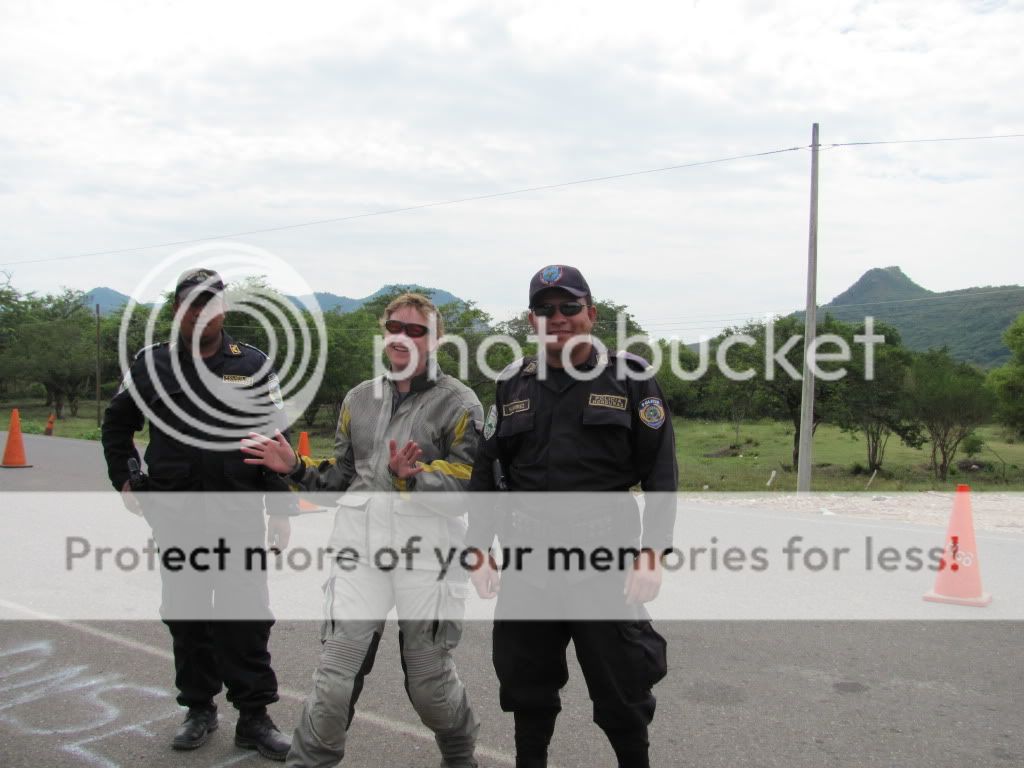
Friendly after all
We finally get to the Honduras/Nicaragua border and to our benefit, the heavens unleashed itself.  The helpers/fixers ran for cover and we didn’t have to much of a hassle with them.  A few money changers followed me around and pointed me in the right direction to get stamped out and into Nicaragua.  An hour later, we were done and had our bikes imported into Nicaragua.  Now with our rain suits on, we made the slow and tedious trek to Chinadega, only 50km away from the border.  It was now 4pm and with the rain, it was getting dark and getting dark quickly.  We have made it a policy not to drive at night; but had no other option as this was the closest town.  We rode really slowly, avoiding the animals on the side of the road and avoiding the several potholes, now filled with water, so you could barley see them.  We finally arrive at one of the hotels that was mentioned in the guide book by nightfall with the rain now easing up.  With the bikes secure, all our wet gear unpacked into the bathroom of our room, walk a few blocks to the town square to have something to eat.  It was the most delicious hotdog either of us ever had.  It was an eventful day and we were in bed early.

Angela's 2 cents:  At the border crossings I was surprised by the age of the pestering "fixers".  I expected them to be annoying little children but instead as Daryll mentioned, they were full grown men that chased us down the road in pickup trucks to the border in order to offer "help". At first it was quite alarming to see these packs of "vultures" several kms away from the border because we weren't really sure we were at the border yet and they were standing in the middle of the road waving at us. While Daryll was doing the paperwork and I was watching the bikes at the border, I actually saw another tourist guy go berzerk on a pack of  fixers following him as he yelled "ENOUGH ALREADY - F### OFF!! LEAVE ME ALONE!!".  I kind of laughed and it made me happy that we had kept our cool despite the heat and harassment.

As for the police checkpoints we crossed, I was surprised that they were established check points, where pylons were set up on the road. I had expected the creeps to appear randomly, come slinking from their hiding spots behind trees and have to make up excuses for stopping us but no, they was quite blatantly organized checkpoints. One strategy I found helpful was to pull up really close to the vehicle in front of me so that we were kind of hidden from the police sight upon approach to the stop point.  That way they were not prepared to stop the expensive motorcycles and we kind of just sailed past them before the dollar signs in their eyes could register..
Digg this

Tuesday, November 16, 2010

The Darién Gap

Daryll writes:

The Darién Gap is a large swath of undeveloped swampland and forest separating Panama's Darién Province in Central America from Colombia in South America. It measures just over 160 km/99 miles long and about 50 km/31 miles wide. Road building through this area is expensive, and the environmental toll is steep. Political consensus in favor of road construction has not emerged, and consequently there is no road connection through the Darién Gap connecting North/Central America (Panama) with South America (Colombia). It is therefore the missing link of the Pan-American Highway; which obviously causes a problem for all overland adventure travelers.
 
End of the Road
There are two options available for bikers; either fly the bike and oneself from Panama to Colombia or sail through the San Blas Islands from Panama to Colombia.  Flying can be done within a day.  The bike is strapped to a pallet and normally is on the same flight as you.  Sailing takes 5 days, 3 of which are through the San Blas Islands and 2 on the open ocean.  Regardless of which option one takes, it is damn expensive to get a bike and oneself across let alone 2 bikes.  However the sailing option worked out slightly cheaper, so we booked a sailing on “Fritz the Cat” from Carti, Panama to Cartagena, Colombia for December 10th.  Coincidentally, our friends Naomi and Alberto have also booked for this sail date, so there will be 4 bikes that we know off on this catamaran.  The captain advertises that he can take 6 bikes.

So far, we haven’t really had a schedule, but now we do.  December 10th isn’t that far off and we need to cross from El Salvador, to Honduras, to Nicaragua, to Costa Rica and into Panama.  I’ve heard of some horror stories of captains getting drunk and leaving their passengers stranded or running out of food and water on-board.  This boat came highly recommended from other bikers that have taken it recently, so we really want to make this date.
Digg this

A New Country

Daryll writes:

It’s always a nervous feeling crossing into a new country so we try and have an early start and not have a big riding day after we into a new country.  We crossed into El Salvador on Sunday, November 14th and spent the night in Santa Ana, a non-descript town.  We arrived early afternoon to find that the entire town had lost it’s power and water supply.  Both came back on around 4pm to our satisfaction as we needed to get caught up on emails and the blog.  We stocked up on some groceries in one of the nicest supermarkets that we’ve come across since the Walmart in La Paz, Mexico.

During our initial planning stages, we thought about crossing from Guatemala into Honduras and visiting the Copan ruins.  After Teotihuacan in Mexico and more recently Tikal in Guatemala, we were all ruined out and as we had decided not to do the northern coastal towns of Honduras which are famous for it’s diving; decided to hit the coast of El Salvador for a few days before crossing into Honduras to make our way to Nicaragua.  The exit out of Guatemala was effortless as we had to cancel our import permits for the bikes, get stamped out and then proceed to the El Salvadorian side.  This process took longer than expected, as we were joking around with the Aduna official, but was painless and we had an interesting conversation nonetheless.  The El Salvadorian Migracion official said that it was not necessary to be stamped into the country; however after insisting as I didn’t want to have problems when we tried to exit, we now have a stamp in our passport that shows that we entered the country.

Aduna - El Salvador
El Salvador literally means "Republic of The Savior" is the smallest, and also the most densely populated country in Central America (Angela's edit: Thanks for the Wikipedia details Billy:). It borders the Pacific Ocean between Guatemala and Honduras.  The colón was the currency of El Salvador between 1892 and 2001, when El Salvador adopted the US Dollar. The Colón continues to still be legal tender though.  We spent about an hour on the Pan-American highway in rush hour traffic on Monday as we made our way to the coastal town of La Libertad and found a Hostel about 100 yards from the beach along Playa El Tunco.  A nice relaxing surf hangout, I spent the afternoon having a siesta on one of the several hammocks hung on the deck and wondered the beach in the evening to watch the sunset.

A Surfers Paradise - Play El Tunco
At last we are up to date with our blog posts. 

Photos added to the El Salvador photo album.
Digg this

Goodbye Mi Bella Guatemala

Angela writes:

It is with mixed feelings that we are now saying hello to El Salvador and goodbye to Guatemala. The excitement of visiting a new country is alluring, however we have marveled at Guatemala’s landscapes, people, and mystery’s for a month now and it has captured a piece of our hearts. There have been so many different flavours of culture to experience in one small area of the world. Hopefully one day we can return to explore some more, although I have felt this way for the US, for Mexico and now for Guatemala so I think we’ll have to do the same motorcycle trip again upon our return!

Guatemala’s population is made up of 40% indigenous Mayan people. The women appear fiercely strong, hardworking and carry everything light or heavy on their heads. My Spanish teacher Dora explained that the women proudly wear their aprons over their woven skirts and blouses, as a uniform of being Mayan and working the land. She also pointed out that during times of celebration Mayan women wear gold earrings, necklaces, rings and bracelets to symbolize that before the Spanish arrived in Guatemala that all the wealth used to be all theirs. Apparently there used to be a big separation between Mayan people and the Ladios (mixed Mayan/Spanish people) but really they are all just striving to be Guatemalans now regardless of origin. Guatemala is still healing from their civil war that only ended about 15 years ago. The army was funded and trained by the US and apparently the army killed about 200,000 indigenous Maya people. Some were involved in guerilla attacks but most weren't doing anything but hanging out in their villages in the middle of no where. An example I found on our map is called Rio Negro. Today the healing process still continues as the mass graves are being exhumed so that bones of people can be returned back to their original villages and family.


My wonderful Spanish teacher Dora also taught me a 1940s Guatemala tribute song. She first sang it on the road side in the middle of nowhere as we were waiting to catch a chicken bus back to the city after visiting the glass factory. I in turn sang the Canadian National Anthem to her (don’t laugh, we don’t have any classic tribute songs!) and Dora liked the part about “God keep our land, glorious and free”. When we returned to the school I insisted that she teach me the song as it was more important to me than learning more verbs! Here it is:

Es mi bella Guatemala un gran pais.
Que en America del Centro puso dios.
Es mi bella Guatemala mi tierra querida, tierra del quetzal (tierra del l’amor)
Sus altas montanas
Sus magicos volcanes
Sus lindas praderas en canto son sin par.

Guatemala is my beautiful great country.
That God put in America's Center.
Guatemala is my beautiful my beloved land, land of the quetzal (land of love)
Its high mountains
Its magic volcanoes
Its beautiful meadows unparalleled.


Dora was so happy that I learned this song and she was so proud that we could sing it walked through the streets of Xela. Dora shared a great deal with me about her life and about Guatemala.  She told me stories about her childhood and remembers once that there was an earthquake so bad that her mother made her and her siblings sleep in the street for 2 nights (along with the rest of the neighbourhood) so they were away from the danger of falling walls and breaking glass in their house. Dora says that was the worst earthquake she ever experienced but now each year there are about 10 to 15 minor ones which do not cause her to lose any sleep. She has never been in danger due to an erupting volcano but she has such a large extended family around the country that anytime there is an explosion she is on the phone ensuring all her family is safe.
Digg this

Monday, November 15, 2010

Tikal

Daryll writes:

After the cascading pools of Semuc Champey, the plan was to ride north to Tikal.  Tikal is one of the largest archaeological sites and urban centers of the Mayan civilization and in 1979 was declared a UNESCO World Heritage Site.

With some wrong turns and losing about 2 hours by following my GPS and not Ang (she had indicated that we should have turned left), we followed a so called dirt highway till we were stopped by a construction crew and learned that we got turned around and were now heading south instead of north.  Ang is the lead rider now.  We only managed to make it to Isla de Flores on Lago Peten for the night and then on to Tikal the next day.  We knew our friends Naomi and Alberto  - Taking the Road South had arrived the previous night and were planning to camp, so we decided to join them as we haven’t camped since Baja.

As you enter the park of Tikal, a guard hands you a slip with the time you enter and reiterates the speed limit of 45 km/hr in the park.  17km down the road as you get to the Hotels, parking and camp spots, a 2nd guard collects the slip and checks the time you arrive.  We deliberately rode really slow as we heard they can actually fine individuals for speeding and took a hard look at the wildlife that we could possible see in the park.  We arrived at the camping area at 9:30am and decided not to set up our tent, but just lock our gear to our bikes, change into shorts and hiking shoes and head to see the ruins.


At a steep 150Q or US $18.75 per person for the entrance fee, we pay and make the 25 min. trek to the Grand Plaza and stumble upon our friends.  There is a bond between bikers that I can’t explain and in particular with Naomi and Alberto, we have gelled and get along really well with them and it is as if we have been friends for years; even though we have only met them twice so far.

The Gang - photo by Alberto
Tikal was the capital of a conquest state that became one of the most powerful kingdoms of the ancient Maya.  Though monumental architecture at the site dates back as far as the 4th century BC, Tikal reached its apogee during the Classic Period,  ca. 200 to 900 AD. During this time, the city dominated much of the Maya region politically, economically, and militarily, while interacting with areas throughout Mesoamerica such as the great metropolis of Teotihuacan in the distant Valley in Mexico.  There is evidence that Tikal was conquered by Teotihuacan in the 4th century AD. Following the end of the Late Classic Period, no new major monuments were built at Tikal and there is evidence that elite palaces were burned. These events were coupled with a gradual population decline, culminating with the site’s abandonment by the end of the 10th century.

Tikal is the best understood of any of the large lowland Maya cities, with a long dynastic ruler  list, the discovery of the tombs of many of the rulers on this list and the investigation of their monuments, temples and palaces.  The city itself covers an area greater than 16 square kilometers (6.2 sq mi) that includes 3000 structures.  We climbed up Temple IV and Temple V that offered up some spectacular views of the surrounding jungle.

Temple IV
View from Temple V
Part of the Grand Plaza
The next morning, we decided to ride as a group as Naomi and Alberto were going to stop in Poptun at an eco-lodge for the night and we were headed to Rio Dulce to camp on the river.  It was an awesome sight though to see 4 fully laden adventure bikes roar down the road and we had turning heads as we passed the little villages.  A day later, our friends show up and we spend another lovely evening over dinner and sharing riding stories.  With a sad farewell the next morning, we head off for another day in Guatemala and our friends head for the Honduras border.

All Guatemala photos added to the album.
Digg this

Friday, November 12, 2010

Cops and Waters (and other natural wonders)

Angela writes:

Since leaving Panajachel we’ve put lots of KMs under our tires and we are now in the far north of the country.  We stopped in Antigua for 3 days where Daryll fell in love with the city and took about 200 photos in less than a day! Boy does he ever love his churches. Upon arrival in Antigua we were welcomed by an American tourist who had bicycled to Guatemala, a very helpful authority from the Tourism office and a man who owns the Honda & Yamaha dealerships in Antigua who recommended where we could buy some new back tires. “Ask and you shall receive”…see I pay attention to churches too;)


We again met up with our motorcycle travelling friends Naomi and Alberto and while we were checking out the free camp site they had scored, we noticed Volcano Fuego blow off some puffs of steam in the distance. Later on that day Daryll and I decided to take a tour to Volcano Pacaya to expand our volcano experience. After driving for a couple hours in a crazy collectivo van, we hiked up Volcano Pacaya to watch the sunset and toast some marshmallows on the heat of the glowing lava we could see deep in the earth.


During one of our days in Antigua we decided to have a typical Guatemalan lunch across the street from a busy, and chaotic market. We walked into the narrow opening of the restaurant and found a nice table in a deep and wide cement dining room. Now for the last 2 months I’ve become quite used to the sound of firecrackers. Children light them off all the time, any time of day, and the sounds of pop–pop-pop are easily recognizable in the distance, which often doesn’t even register as a sound in my consciousness anymore. On this particular day we ordered a delicious soup with squash, potatoes and big chunks of beef with rice and tortillas on the side. Muy buena!  Suddenly these huge cracking noises of eardrum damaging decibel, erupted on the street in front of the restaurant, echoing loud and terrifying. Immediately my brain decided there must have been a drive-by-shooting at the market across the street and so I dove off my chair, onto the cold cement floor of the restaurant.  Now I didn’t expect masked gunmen to come through the front door per say, but I figured under the table I would at least be safe from flying debris. I looked up at Daryll still sitting comfortably on his chair and was just about to pull him to the safety of the floor when it dawned on me that the cracking sounds out on the street was not in fact gun fire but most likely the sound of fire crackers up much more close and personal than what I’ve become accustomed to.  I immediately jumped back into my chair and hoped that nobody in the restaurant but Daryll, noticed my gross overreaction. Unfortunately that was not the case and the girl from the next table left her lunch to come over to make sure I was okay. Except for my terminal embarrassment, I laughed away the kind concern. Unknown to the other spectators, my hands continued to shake the rest of the way through lunch as Daryll glowingly admired my fierce survival skills.

After Antigua we had to drive through Guatemala City to get to our Northern destinations, so we decided that early Sunday morning would be the best way to avoid traffic and any dangers of city.  By 7:30 am we were meandering our way through the capital city and Daryll had stopped to ask for directions from a group of cops and army guys on motorcycles.  Instead of directing us, they all decided to lead us safely through the city on a little 5 motorcycle parade. By 8 am we were safely on the other side of the city, and on our way to our hardy breakfast destination. 
 

How to Navigate thru' Guatemala City from Daryll Naidu on Vimeo.

The next couple of nights we stayed in a beautiful hostel, in the middle of the mountains, in a town called Lanquin and we got there by riding a 20 km switch-backing, dirt road down into a valley.  Our purpose was to visit a beautiful natural water wonderland called Semuc Champey.   To visit the park we left the hostel with 4 other tourists and stood in the back of a pickup truck, hanging on to metal bars – not unlike Wayne Gretzky arrival to light the Winter Olympic cauldron. We drove another 15 km into deep, muddy valley and only felt like the truck was going to roll over the cliffs to our deaths a couple times;)  Semuc Champey in Maya language means “Hidden Deep in the Rocks”.  It’s a raging river, flowing down a valley that suddenly plunges into the earth, into a deep dark, treacherous cave.   Overtop of where the river disappears, there is a sold limestone roof that catches the trickling water that comes running down from the lush green jungle mountains surrounding the area. The water on top of the limestone creates collections of turquoise pools of water and is spread out over about 15 different cascading shelf layers.  It is like a natural infinity pool with waterfalls dropping from each pool into the pool below, and beside it.  Each pool is heated by the sun and are absolutely perfect for swimming in. Eventually the underground river connects to the last pool and all the water collects together again. We spent the day hiking up the mountain to get the perfect overview of all the pools and then for the rest of the afternoon we cooled down by swimming and lazing in the multiple pools.


Digg this

Friday, November 5, 2010

Lago Atitlan

Daryll writes:

We hadn’t been on the bikes for just over 2 weeks and it was good to be back in the saddle.  The route between Xela and Panajachel on Lago Atitlan was on the Pan American Highway and was a fabulous smooth dual lane highway at the start of the day.  It progressively got worse and in many spots, the highway was diverted to the opposite side of the road and now turned into a single lane obstacle course.  Much of the Pan American was destroyed due to the massive landslides both Mexico and Guatemala suffered about a month ago.  If this is what the Pan American Highway looked like, I don’t even want to think what the other secondary or country roads look like.

On the way to Panajachel which is located on one of the 3 largest lakes in Guatemala and surrounded by 3 volcanoes (non-active), we dropped from an elevation of 2,999m/9,839ft to 1,589m/5,213ft in under 45 minutes.  The road leaving the Pan American down to Panajachel was a steep, twisty, pot-holed road and was slow going.  There were some freshly paved sections though, but this didn’t last for long.  We spent 2 days in Panajachel and wondered around visiting the lake several times during the course of the day and evening to try and get a cloud-free view of the volcanoes situated on the other side of the lake.  I also managed to get some bike maintenance in by checking and tightening all the bolts and cleaning and lubing the chains.  We were originally going to camp; however after inquiring about the cost of camping thought better of it and managed to get a hotel for the same price and only a block away from the lake.

Volcan San Pedro
Panajachel
Sunset over Lago Atitlan
Over the last few weeks, I have been corresponding with a couple from Salt Spring Island, BC, who are also doing a similar trip (Naomi & Alberto – Taking the Road South) and riding 2 BMW F800GS’s, so we planned to meet up. We missed each other earlier in the day, but finally got together for dinner and it was great talking to them about their experiences.  They are such a fun pair.  We hope to meet up with them again in Antigua and I’m sure our paths will cross several times over the next few months.

Naomi & Alberto
Since leaving Xela, I feel that we are on a whole new trip due to the amount of Spanish both Ang. and I have picked up.  We are better able to communicate and ask the questions that we need, whether it be directions or even reading a menu, and I’m sure that the more practice we get in, the better we will become.  I have even got to the point where I can joke around with either street vendors or waiters that are pestering us to either buy their merchandise or visit their restaurant and we all have a good laugh at the end.

Now being on the road in Guatemala for a few days now, I can swear that Guatemaltecos are the worst drivers that we have encountered thus far.  All drivers have a death wish especially the bus and taxi drivers.  They have no hesitation in cutting you off, passing on blind corners and accelerating when there are clearly warning signs indicating one to slow down. 

After Panajachel, we got back on the Pan American to head to Antigua.  As we had set out pretty early in the morning, it was foggy out and we could barely see 100m in front of us; so it was slow going.  We had to keep our visors open as they would constantly mist up, which meant that it was really cold.  On the way to Antigua, passing through one of the towns, I caught footage of this, it is not everyday that you see bus passengers climb out the back of a bus.

oneworld2explore - vid 3 from Daryll Naidu on Vimeo.


New photos added to the Guatemala photo album.
Digg this

Monday, November 1, 2010

Día de los Muertos …

Daryll writes:

Dia de los Muertos or Day of the Dead is celebrated in Guatemala, Mexico and most of Latin America on November 1st.  It is a holiday and focuses on gatherings of family and friends to pray for and remember friends and family members who have died.  Traditions connected with the holiday include building private altars honoring the deceased using sugar skulls, wreaths, flowers and the favorite foods and beverages of the departed and visiting graves with these as gifts.  The Day of the Dead is a time of celebration, where partying is common and families gather around the grave site to socialize and dine.  Families go to cemeteries to be with the souls of the departed.  The intent is to encourage visits by the souls, so that the souls will hear the prayers and the comments of the living directed to them. Celebrations can take a humorous tone, as celebrants remember funny events and anecdotes about the departed. 

On Sunday, Oct. 31st, we wondered around the square and happened to come upon these designs made up by different school and church groups to resemble a carpet.  It is actually saw dust that is spray painted into the patterns desired.  Once everyone got to admire their creations, a procession followed which went right over their wonderful work.  The procession was led by different church groups and many of the ladies were in traditional dress.

Carpet of saw dust
Rich in color
I wandered through the cemetery this morning and by 9:30am, things were already busy and were expected to get crazy later in the afternoon.  There were vendors everywhere; selling flowers to clothes, to toys and the staple tacos.  At times, I was shoulder to shoulder as I plodded along through the narrow alley of an entrance into the cemetery.  Once past the vendors and inside the grounds, it eased up as people dispersed to the different grave sites.  Families were washing and cleaning out their family grave sites and placing fresh flowers around the grave.  Some went to the extent of hiring bands to play for the dead; whilst others brought little stools, the family dog and relaxed on their day off.

Fiesta time


Everyone busy decorating


Digg this